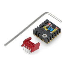
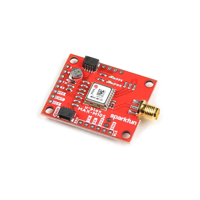
GNSS MAX-M10S module - Qwiic - SparkFun GPS-18037
- Артикул:
- 57945888


Характеристики
Прочие свойства
- Бренд
- SparkFun
Описание
SparkFun GNSS Receiver Breakout is a high-quality GNSS receiver with a built-in MAX-M10S chip and an SMA antenna connector. It enables simultaneous reception and processing of signals from GPS , GLONASS , Galileo and BeiDou with a horizontal accuracy of up to 1.5 m . Supports bands L1C / A / E1-B / C / L1OF and B1I . The module also supports NMEA and UBX protocols via I2C or UART interfaces.
The product is compatible with Arduino! The manufacturer has prepared a detailed user guide - check it out!
SparkFun GNSS Receiver Breakout - GNSS MAX-M10S receiver with Qwiic connector.
GNSS stands for Global Navigation Satellite Systems and stands for a global navigation system that covers the entire earth. The most important task of GNSS is determining the user's position. The GNSS systems also include the GPS Global Positioning System and GLONASS. Are you wondering how satellite navigation works? It is a type of radio navigation, which is why it uses radio waves that are broadcast from artificial satellites to determine the position of points and moving receivers along with the parameters of their movement on the Earth's surface.
The outputs of the modules are Qwiic connectors and solder pads.
MAX-M10S GNSS module - Qwiic - SparkFun GPS-18037.
- Built-in chip: MAX-M10S
- Module type: GNSS receiver
- Receiving data from positioning systems: GPS, GLONASS, Galileo and BeiDou
- Band reception:
- GPS: L1C / A (1575.42 MHz)
- Galileo: E1-B / C (1575.42 MHz)
- GLONASS: L1OF (1602 MHz + k * 562.5 kHz, k = –7, ..., 5, 6)
- BeiDou: B1I (1561.098 MHz)
- Integrated SMA connector (antenna not included)
- Horizontal accuracy: 1.5 m
- Maximum altitude: 80,000 m
- Maximum update rate: 10 Hz
- Maximum G: ≤ 4
- Start-up time:
- cold start - 24 seconds
- hot start - 1 second
- Maximum speed: 500 m / s
- Speed accuracy: 0.05 m / s
- Course accuracy: 0.3 degrees
- Time Pulse Accuracy: 30 ns
- Supply voltage: 3.3 V
- Current consumption: from 6 mA to 25 mA (depending on operating conditions)
- 2 x Qwiic connector
- Communication interface: I2C bus, UART
- I2C interface address: 0x42 (software configurable)
- Supported protocols: NMEA and UBX via I2C or UART interfaces
- Dimensions of the board with an SMA connector: 44.2 x 30.48 mm
- The website of the manufacturer: SparkFun GPS-18037
- User Guide
- Layout diagram
- EagleCAD files
- Tile dimensions
- Technical Documentation
- Integration instruction
- u-blox ECCN
- Arduino library
- GitHub repository